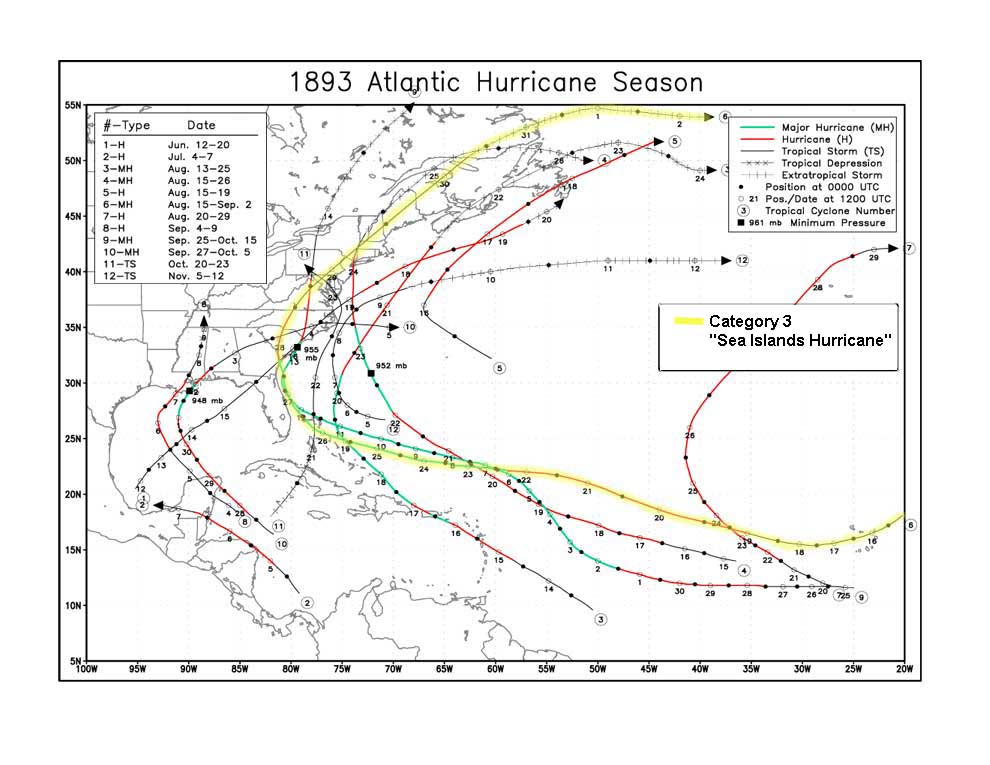
1893 Sea Islands hurricane
| Category 3 major hurricane (SSHWS/NWS) | |
 Damaged houses in Beaufort, South Carolina | |
| Formed | August 15, 1893 |
|---|---|
| Dissipated | September 2, 1893 |
| Highest winds |
1-minute sustained: 120 mph (195 km/h) |
| Lowest pressure | 954 mbar (hPa); 28.17 inHg |
| Fatalities | 1000-2000 |
| Damage | $1 million (1893 USD) |
| Areas affected | Georgia, South Carolina |
| Part of the 1893 Atlantic hurricane season | |
On August 27, 1893, a major hurricane which came to be known as the Sea Islands Hurricane struck the United States near Savannah, Georgia.[1] It was one of three deadly hurricanes during the 1893 Atlantic hurricane season; the storm killed an estimated 1,000–2,000 people, mostly from storm surge. This is also the storm that made famous United States Life-Saving Service Keeper Dunbar Davis.
Meteorological history

Modern analysis of historical records has allowed the history of this storm to be pieced together, although the analysis is only an estimate since few accurate meteorological records were taken.
On August 15, 1893, a tropical storm formed east of Cape Verde. It likely passed directly through the islands on the 16th, leaving their vicinity during the evening of the 17th. It became a hurricane on the 19th, while crossing the Atlantic between the Cape Verde Islands and the Lesser Antilles. The hurricane continued to strengthen, attaining Category 3 status on August 22 while located northeast of the Lesser Antilles. By the evening of the 25th, the storm was approaching the Bahamas. During the approach it began to deviate from its westerly course and arc west-northwest. It is believed that the first effects of the storm were beginning to be felt in the Sea Islands area, with the winds steadily increasing during the night of the 25th.
Some of the inhabitants anticipated the storm and left the islands as quickly as possible. The conditions soon rapidly deteriorated on the island and the hurricane passed over sometime on the 26th. By now the hurricane was turning more and more towards the north. It moved parallel to the coast for about one hundred miles before making landfall.
Landfall occurred near Savannah, Georgia, on August 27. Reports from the time say that wind during landfall was around 120 mph (190 km/h), making it a category 3 storm. Pressure in Savannah was measured at 960 mbar (28 inHg); modern estimates put the pressure around 954 mbar (28.2 inHg) at landfall, and possibly as low as 931 mbar (27.5 inHg) out at sea. This would have made the hurricane most likely stronger than a Category 3 storm on the Saffir–Simpson Hurricane Scale. The hurricane passed north over South Carolina on August 28 and moved up the U.S. East Coast before becoming extratropical over Atlantic Canada.
Impact

The hurricane carried with it a heavy storm surge (16 ft or 4.9 m, according to Clara Barton, although the modern NOAA SLOSH model calculates that some areas may have been inundated up to 30 feet[2]), which caused great destruction along the coastline and offshore Sea Islands in Georgia and South Carolina. An estimated 1,000 to 2,000 people were killed (mostly by drowning), putting it on-par with 2005's Hurricane Katrina as the fourth deadliest hurricane in US history. St. Helena was estimated to have 6,000 Negroes living there while 2,000 were women. The majority of the Negroes owned land there and some rented. A lot of structures in that area were not elevated higher than 2 feet; therefore, they were covered by the first waves that went above the normal water mark.[3]
Although the hurricane was devastating, the American Red Cross did not arrive until October 1, possibly because of ongoing efforts following another hurricane that hit South Carolina in June. After the Red Cross arrived, a warehouse of clothing and food was started at Beaufort, South Carolina, to provide services to the affected. Relief efforts were impeded by a second Category 3 hurricane that struck just north of the area, near Charleston, South Carolina, on October 13. During a massive 10-month relief campaign, success was declared, with the Sea Islands population living in decent houses producing their own food again. Damages from the storm totaled to at least $1 million (1893 USD).[4]
Damage was reported as far north as Maine. Some areas, particularly New York City and Long Island, were already reeling from what later came to be known as the 1893 New York hurricane that had struck the region just days before, on August 24, and were damaged anew by this storm. "Immense" damage was reported to shade trees and telegraph and telephone wires in Washington. In Annapolis, Maryland "hardly a tree was left standing" and Baltimore reported the worst flooding since 1868. In New Jersey, damage was "heavy" in the New Brunswick area, and many trees were downed and roofs were blown off in Trenton. Damage was heavy all along the New Jersey coast and breakers were described as the biggest ever witnessed. Railroad tracks were under four feet of water between Bay Head and Berkley. In New York, several lives were lost in The Rockaways, and a number of people were killed at points along the Hudson River when tow boats were destroyed. Crops were heavily damaged in Pennsylvania and upstate New York. Boats were wrecked and sunk in the Dunkirk area. In Brooklyn, where 13 houses under construction were destroyed, damage was "severe" and Gravesend Bay was "littered with the wrecks of small yachts and boats." In Coney Island, roofs were lifted off big buildings and carried for blocks. Waves topped the seawall by 15 feet at Battery Park. Damage was heavy at resorts on Long Island and it was the worst storm on the New England coast in 20 years. [5][6][7][8]
See also
- List of tropical cyclones
- List of Atlantic hurricanes
- List of New England hurricanes
- 1893 Cheniere Caminada Hurricane
- 1893 Charleston Hurricane
- Hurricane Matthew
- Dunbar Davis
- List of Florida hurricanes
- List of North Carolina hurricanes
References
- ↑ Christine Gibson "Our 10 Greatest Natural Disasters," American Heritage, Aug./Sept. 2006.
- ↑ NOAA SLOSH model
- ↑ "SEA ISLANDS OVERWHELMED: STEADILY THE LIST OF CYCLONE VICTIMS GROWS. CORONER'S ESTIMATE OVER 750 DEAD". New York Times Database. September 3, 1893. Retrieved June 2, 2013.
- ↑ David Longshore Encyclopedia of Hurricanes, Typhoons, and Cyclones pg. 286
- ↑ Storm Swept Particulars of the Ruin brought by The Great Gale Many Points in New York, New Jersey and Pennsylvania SUFFER GREAT DAMAGE The Girard Guit September 1, 1893
- ↑ Struck by a Cyclone Paterson Daily Press August 29, 1893
- ↑ Huge Tidel Wave The Miamisburgh Bulletin September 1, 1893
- ↑ New York's Storm It was a Veritable Tornado One of The Worst Ever Experienced The Lawrence Daily August 30, 1893
Further reading
- Jones, Katharine M. (1960). "The Big Storm of 1893". Port Royal Under Six Flags, The Story of the Sea Islands. Indianapolis & New York: The Bobbs-Merrill Company.
- Marscher, William; Marscher, Fran (2004). The Great Sea Island Storm of 1893. Macon, GA: Mercer University Press. ISBN 0-86554-867-6.
- Satterthwait, Elisabeth Carpenter (1898). A Son of the Carolinas, A story of the Hurricane upon The Sea Islands. Philadelphia, Pa.: Henry Altemus. 273 pp. ISBN 0-8369-9062-5 (ISBN 0-8369-9062-5) -- a historical-fiction account from the perspective of the people affected.
External links
- Cyclone of 1893
- NOAA Hurricane Track
- August 27 in Georgia history
- Beaufort County Public Library hurricane history
- North Florida & Coastal Georgia hurricanes, 1565-1899
- UNISYS 1893 hurricane tracks
The Lowcountry of South Carolina | ||
|---|---|---|
| Counties | 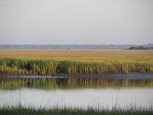 | |
| Major communities | ||
| Sea Islands | ||
| History & culture | ||
| Military installations | ||
| Natural areas | ||
| Other articles | ||