10th arrondissement of Paris
| 10th arrondissement of Paris | |
|---|---|
| French municipal arrondissement | |
|
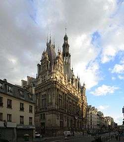
The town hall of the 10th arrondissement (rue du Faubourg Saint-Martin). | |
 Paris and its closest suburbs | |
| Country | France |
| Region | Île-de-France |
| Department | Paris |
| Commune | Paris |
| Government | |
| • Mayor | Tony Dreyfus |
| Area | |
| • Total | 2.89 km2 (1.12 sq mi) |
| Population (8 March 1999 census)[p] | |
| • Total | 89,612 |
| • Estimate (2005) | 88,800 |
| • Density | 31,000/km2 (80,000/sq mi) |
| ^[p] Population sans doubles comptes: single count of residents of multiple communes (e.g. students and military personnel). | |
 20 arrondissements of Paris | |||||||||||||||||||||||||||||||||||||
|---|---|---|---|---|---|---|---|---|---|---|---|---|---|---|---|---|---|---|---|---|---|---|---|---|---|---|---|---|---|---|---|---|---|---|---|---|---|
| |||||||||||||||||||||||||||||||||||||
The 10th arrondissement of Paris is one of the 20 arrondissements (administrative districts) of the capital city of France.
Situated on the right bank of the River Seine, the arrondissement contains two of Paris's six main railway stations: the Gare du Nord and the Gare de l'Est. Built during the 19th century, these two termini are among the busiest in Europe.
The 10th arrondissement also contains a large portion of the Canal Saint-Martin, linking the northeastern parts of Paris with the River Seine.
Geography
The land area of the arrondissement is 2.892 km2 (1.117 sq. miles, or 715 acres), and it had a 1999 population of 89,695.
The 10th arrondissement is often referred to as l'Entrepôt. Like all Parisian arrondissements, it is divided into four quartiers (districts):[1]
- Saint-Vincent-de-Paul, the 37th quartier, has 21,624 people in an area of 92.7 hectares
- Porte-Saint-Denis, the 38th quartier, has 15,066 people in an area of 47.2 hectares
- Porte-Saint-Martin, the 39th quartier, has 23,125 people in an area of 60.9 hectares
- Hôpital-Saint-Louis, the 40th quartier, has 29,870 people in an area of 88.4 hectares
Demography
The peak population of the 10th arrondissement occurred in 1881, when it had 159,809 inhabitants. Today, the arrondissement remains very dense in both population and business activity, with 89,612 inhabitants and 71,962 jobs at last census in 1999. Due to its large Turkish minority, the 10th arrondissement is often called "La Petite Turquie" (Little Turkey).[2]
Historical population
| Year (of French censuses) |
Population | Density (inh. per km²) |
|---|---|---|
| 1872 | 135,392 | 46,848 |
| 1881 (peak of population) | 159,809 | 55,259 |
| 1954 | 129,179 | 44,699 |
| 1962 | 124,497 | 43,049 |
| 1968 | 113,372 | 39,202 |
| 1975 | 94,046 | 32,519 |
| 1982 | 86,970 | 30,073 |
| 1990 | 90,083 | 31,149 |
| 1999 | 89,612 | 30,986 |
| 2009 | 95,911 | 33,187 |
Immigration
| |||||||||||||||||||
Map

Cityscape
-
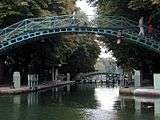
The canal Saint-Martin.
-

Place de la République
-
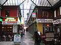
Passage Brady
-

Gare du Nord


Places of interest
- Canal Saint-Martin
- Gare de l'Est
- Gare du Nord
- Musée de l'Éventail (museum of fans)
- Passage Brady
- Passage du Prado
- Porte Saint-Denis
- Porte Saint-Martin
- Church of Saint-Vincent-de-Paul
- Church of Saint-Laurent
Mains streets and squares
Streets
|
|
|
|
Squares
|
|
References
- ↑ All demographic figures are from the Mairie de Paris, 1999.
- ↑ Le Petit Journal. ""LA PETITE TURQUIE" - Balade dans le quartier turc de Paris". Retrieved 2014-12-14.
External links
| Wikimedia Commons has media related to 10th arrondissement of Paris. |
-
 10th arrondissement travel guide from Wikivoyage
| ||
Coordinates: 48°52′31.83″N 2°21′28.27″E / 48.8755083°N 2.3578528°E