Ōme, Tokyo
| Ōme 青梅市 | |||
|---|---|---|---|
| City | |||
|
Ōme City Hall | |||
| |||
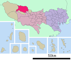 Location of Ōme in Tokyo | |||
 Ōme
| |||
| Coordinates: 35°47′16.7″N 139°16′33″E / 35.787972°N 139.27583°ECoordinates: 35°47′16.7″N 139°16′33″E / 35.787972°N 139.27583°E | |||
| Country | Japan | ||
| Region | Kantō | ||
| Prefecture | Tokyo | ||
| Area | |||
| • Total | 103.31 km2 (39.89 sq mi) | ||
| Population (February 2016) | |||
| • Total | 136,071 | ||
| • Density | 1,320/km2 (3,400/sq mi) | ||
| Time zone | Japan Standard Time (UTC+9) | ||
| Symbols | |||
| • Tree | Cryptomeria japonica | ||
| • Flower | Prunus mume | ||
| • Bird | Cettia diphone | ||
| Phone number | 0428-22-111 | ||
| Address | 1-11-1 Higashi-ome, Ome-shi, Tokyo 198-8701 | ||
| Website |
www | ||


Ōme (青梅市 Ōme-shi) is a city located in the western portion of Tokyo Metropolis, in the central Kantō region of Japan. As of 1 February 2016, the city had an estimated population of 136,071 and a population density of 1320 persons per km². Its total area was 103.31 square kilometres (39.89 sq mi). The city's name literally means green ume, or Japanese apricot.
Geography
Ōme is located in the Okutama Mountains of western Tokyo, bordered by Saitama Prefecture to the north. The Tama River and Iruma River flow through the city.
Surrounding municipalities
- Tokyo Metropolis
- Hinode to the south
- Hamura to the southeast
- Okutama, Tokyo to the west
- Akiruno to the south
- Saitama Prefecture
Climate
| Climate data for Ōme (1981 - 2010) | |||||||||||||
|---|---|---|---|---|---|---|---|---|---|---|---|---|---|
| Month | Jan | Feb | Mar | Apr | May | Jun | Jul | Aug | Sep | Oct | Nov | Dec | Year |
| Record high °C (°F) | 18.3 (64.9) |
24.0 (75.2) |
25.0 (77) |
32.7 (90.9) |
34.7 (94.5) |
35.7 (96.3) |
38.5 (101.3) |
38.0 (100.4) |
36.8 (98.2) |
31.3 (88.3) |
26.4 (79.5) |
26.2 (79.2) |
38.5 (101.3) |
| Average high °C (°F) | 8.8 (47.8) |
9.4 (48.9) |
12.5 (54.5) |
18.4 (65.1) |
22.5 (72.5) |
25.0 (77) |
28.8 (83.8) |
30.4 (86.7) |
26.1 (79) |
20.7 (69.3) |
15.7 (60.3) |
11.3 (52.3) |
19.1 (66.4) |
| Daily mean °C (°F) | 2.8 (37) |
3.7 (38.7) |
6.9 (44.4) |
12.6 (54.7) |
17.0 (62.6) |
20.4 (68.7) |
24.1 (75.4) |
25.5 (77.9) |
21.6 (70.9) |
15.9 (60.6) |
10.2 (50.4) |
5.3 (41.5) |
13.8 (56.8) |
| Average low °C (°F) | −2.5 (27.5) |
−1.7 (28.9) |
1.6 (34.9) |
7.0 (44.6) |
12.0 (53.6) |
16.5 (61.7) |
20.4 (68.7) |
21.6 (70.9) |
18.0 (64.4) |
11.8 (53.2) |
5.4 (41.7) |
0.1 (32.2) |
9.2 (48.6) |
| Record low °C (°F) | −8.9 (16) |
−9.2 (15.4) |
−7.4 (18.7) |
−2.5 (27.5) |
3.5 (38.3) |
8.9 (48) |
12.5 (54.5) |
15.5 (59.9) |
8.0 (46.4) |
1.4 (34.5) |
−3.5 (25.7) |
−6.8 (19.8) |
−9.2 (15.4) |
| Average precipitation mm (inches) | 44.2 (1.74) |
48.5 (1.909) |
89.6 (3.528) |
108.9 (4.287) |
120.0 (4.724) |
161.5 (6.358) |
183.1 (7.209) |
227.7 (8.965) |
237.1 (9.335) |
170.0 (6.693) |
78.0 (3.071) |
39.3 (1.547) |
1,507.8 (59.362) |
| Average precipitation days (≥ 1.0 mm) | 4.5 | 5.3 | 9.6 | 9.6 | 10.8 | 13.1 | 13.5 | 11.2 | 13.1 | 10.4 | 6.8 | 4.1 | 112 |
| Mean monthly sunshine hours | 186.1 | 175.0 | 172.1 | 177.4 | 167.4 | 119.5 | 136.5 | 166.2 | 122.2 | 133.3 | 152.2 | 180.6 | 1,888.6 |
| Source #1: Japan Meteorological Agency | |||||||||||||
| Source #2: 観測史上1〜10位の値(年間を通じての値) | |||||||||||||
History
The area of present-day Ōme was part of ancient Musashi Province. Ōme developed in the Edo period as a post station on the Ōme-Kaidō highway. In the post-Meiji Restoration cadastral reform of July 22, 1878, the area became part of Nishitama District in Kanagawa Prefecture. The town of Ōme was created on April 1, 1889 with the establishment of municipalities law. Nishitama District was transferred to the administrative control of Tokyo Metropolis on April 1, 1893. Ōme was elevated to city status on April 1, 1951 by merging with the neighboring villages of Kasumi and Chōfu. Later in 1955, four additional villages (Yoshida, Mita, Kosoki, and Nariki) merged with Ōme.
Education
- Meisei University - Ōme campus
- Ōme has 17 public elementary schools and 11 public middle schools operated by the city government. The city has two public high schools operated by the Tokyo Metropolitan Board of Education.
Transportation
Railway
- JR East - Ōme Line
- Kabe - Higashi-Ōme - Ōme - Miyanohira - Hinatawada - Ishigamimae - Futamatao - Ikusabata - Sawai - Mitake
- Mitake Tozan Railway
Highway
Sister city relations
Local attractions
- Ome Railway Park
- Ome Marathon
- Mount Mitake
- Mitake Shrine
References
- ↑ "International Exchange". List of Affiliation Partners within Prefectures. Council of Local Authorities for International Relations (CLAIR). Retrieved 1 July 2016.
External links
| Wikimedia Commons has media related to Ome, Tokyo. |
- Ōme City official website (Japanese)