Å, Moskenes
| Å Å i Lofoten | |
|---|---|
| Village | |
|
View of the village of Å | |
 Å  Å Location in Nordland | |
| Coordinates: 67°52′45″N 12°58′59″E / 67.87917°N 12.98306°ECoordinates: 67°52′45″N 12°58′59″E / 67.87917°N 12.98306°E | |
| Country | Norway |
| Region | Northern Norway |
| County | Nordland |
| District | Lofoten |
| Municipality | Moskenes |
| Elevation[1] | 10 m (30 ft) |
| Time zone | CET (UTC+01:00) |
| • Summer (DST) | CEST (UTC+02:00) |
| Post Code | 8392 Sørvågen |
| Climate | Cfc |
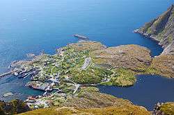
Å (Norwegian pronunciation: [oː], from å meaning "stream") is a village in the municipality of Moskenes in Nordland county, Norway. It is located towards the southern end of the Lofoten archipelago. It is connected to the rest of the archipelago by the European route E10 highway. This part of the highway is also called King Olav's Road.
Until the 1990s, Å was mainly a small fishing village specializing in stockfish, but since then tourism has taken over as the main economic activity. The town features the Lofoten Stockfish Museum and the Norwegian Fishing Village Museum as two big tourist attractions. In May 2004, Å became the starting point of a cycling trip from A to B (with B represented by Bee, Nebraska).[2]
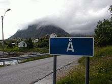
Name
The village (originally a farm) is first mentioned in 1567 ("Aa"). The name is from Old Norse á which means "(small) river". The name was spelled Aa until 1917 when the Norwegian language reform changed the letter aa to å. The village is sometimes referred to as Å i Lofoten ("i" means "in") to distinguish it from other places named Å (see Å (disambiguation)).
References
- ↑ "Å" (in Norwegian). yr.no. Retrieved 2012-06-13.
- ↑ Parry, Paul. "From A to B. Literally.". Archived from the original on 15 August 2012.
External links
| Wikivoyage has a travel guide for Å. |
| Wikimedia Commons has media related to Å. |