National Register of Historic Places listings in Glynn County, Georgia
This is a list of properties and districts in Glynn County, Georgia that are listed on the National Register of Historic Places (NRHP).
- This National Park Service list is complete through NPS recent listings posted December 2, 2016.[1]
Current listings
| [2] | Name on the Register | Image | Date listed[3] | Location | City or town | Description |
|---|---|---|---|---|---|---|
| 1 | Ballard School |  |
(#04001181) |
323 Old Jesup Hwy. 31°12′17″N 81°30′22″W / 31.20460°N 81.50619°W |
Brunswick | |
| 2 | Brunswick Old Town |  |
(#74000683) |
Address Restricted |
Brunswick | An archeological area seven blocks long and three blocks wide along Bay Street, it was leveled in 1974 (from NRHP #79000727) |
| 3 | Brunswick Old Town Historic District |  |
(#79000727) |
Roughly bounded by 1st, Bay, New Bay, H and Cochran Sts. 31°08′43″N 81°29′29″W / 31.145278°N 81.491389°W |
Brunswick | An area slightly larger than the original city plan |
| 4 | Colored Memorial School and Risley High School |  |
(#02001290) |
1800 Albany St. 31°09′20″N 81°29′28″W / 31.15563°N 81.49100°W |
Brunswick | |
| 5 | Faith Chapel |  |
(#71000277) |
Old Plantation Rd. 31°03′38″N 81°25′18″W / 31.060556°N 81.421667°W |
Jekyll Island | |
| 6 | Fort Frederica National Monument | 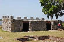 |
(#66000065) |
12 mi. N of Brunswick 31°13′26″N 81°23′36″W / 31.22384°N 81.39324°W |
St. Simons Island | administered by the National Park Service |
| 7 | Glynn Academy |  |
(#11000775) |
Southeast corner of Egmont and Monck Sts. 31°08′55″N 81°29′26″W / 31.14864°N 81.49062°W |
Brunswick | Apparently the 1840 Glynn Acad. Building is on the NRHP itself, while three buildings are contributing properties to Brunswick Old Town HD |
| 8 | Hamilton Plantation slave cabins | .jpg) |
(#88000968) |
Address Restricted (on Gascoigne Bluff) 31°10′16″N 81°24′28″W / 31.17106°N 81.40771°W |
St. Simons Island | Two unusually well-built slave cabins (a duplex), built before 1833; summer tours given by Cassina Garden Club |
| 9 | Hofwyl-Broadfield Plantation |  |
(#76000635) |
N of Brunswick at 5556 U.S. Highway 17 North 31°18′18″N 81°27′13″W / 31.30500°N 81.45366°W |
Brunswick | Rice plantation from 1800 to 1915, the main house was built in the early 1850s. Now a Georgia state historic site. |
| 10 | Horton-duBignon House, Brewery Ruins, duBignon Cemetery |  |
(#71000278) |
Riverview Dr. 31°06′06″N 81°24′52″W / 31.10177°N 81.41456°W |
Jekyll Island | May be known as Horton House |
| 11 | Jekyll Island Club |  |
(#72000385) |
Between Riverview Dr. and Old Village Blvd. 31°03′34″N 81°25′20″W / 31.059444°N 81.422222°W |
Jekyll Island | Ths historic district is a National Historic Landmark. |
| 12 | King and Prince Hotel |  |
(#04001465) |
201 Arnold Rd. 31°08′21″N 81°22′44″W / 31.13921°N 81.37902°W |
St. Simons Island | |
| 13 | Needwood Baptist Church and School |  |
(#98001520) |
US 17, 1 mi. S of Hofwyl-Broadfield Plantation State Historic Site. 31°16′55″N 81°26′27″W / 31.28207°N 81.44079°W |
Brunswick | |
| 14 | Rockefeller Cottage |  |
(#71000279) |
331 Riverview Dr. 31°03′27″N 81°25′19″W / 31.0575°N 81.421944°W |
Jekyll Island | Also known as Indian Mound Cottage |
| 15 | St. Simons Lighthouse and Lighthouse Keepers' Building |  |
(#72000386) |
600 Beachview Dr. 31°08′03″N 81°23′37″W / 31.13411°N 81.39357°W |
St. Simons Island | |
| 16 | Strachan House Garage |  |
(#97000660) |
414½ Butler Ave. 31°08′07″N 81°23′53″W / 31.135278°N 81.398056°W |
St. Simons | |
| 17 | US Coast Guard Station-St. Simons Island |  |
(#98000297) |
4201 First St. 31°08′44″N 81°22′23″W / 31.14562°N 81.37316°W |
St. Simons Island | Now houses the Maritime Center museum |
| 18 | United States Post Office and Court House |  |
(#14000153) |
805 Gloucester 31°09′01″N 81°29′33″W / 31.150240°N 81.492427°W |
Brunswick | Frank M. Scarlett Federal Building houses the Post Office and Federal Court |
| 19 | Windsor Park Historic District | |
(#13000877) |
Bounded by Lanier Blvd., Walnut Ave., Gloucester & Magnolia Sts. 31°08′57″N 81°28′56″W / 31.149081°N 81.482334°W |
Brunswick |
References
- ↑ "National Register of Historic Places: Weekly List Actions". National Park Service, United States Department of the Interior. Retrieved on December 2, 2016.
- ↑ Numbers represent an ordering by significant words. Various colorings, defined here, differentiate National Historic Landmarks and historic districts from other NRHP buildings, structures, sites or objects.
- ↑ The eight-digit number below each date is the number assigned to each location in the National Register Information System database, which can be viewed by clicking the number.
| Wikimedia Commons has media related to National Register of Historic Places in Glynn County, Georgia. |
| Topics | |
|---|---|
| Lists by states |
|
| Lists by insular areas | |
| Lists by associated states | |
| Other areas | |
| |
This article is issued from Wikipedia - version of the 6/27/2016. The text is available under the Creative Commons Attribution/Share Alike but additional terms may apply for the media files.