Eureka Springs Historic District
|
Eureka Springs Historic District | |
|
Spring Street in the district | |
  | |
| Location | Most of Eureka Springs and its environs, Eureka Springs, Arkansas |
|---|---|
| Coordinates | 36°24′6″N 93°44′18″W / 36.40167°N 93.73833°WCoordinates: 36°24′6″N 93°44′18″W / 36.40167°N 93.73833°W |
| Area | 1,250 acres (510 ha) |
| Architectural style | Late Victorian, Late 19th and 20th Century Revivals, Bungalow (original) |
| NRHP Reference # |
70000118 (original) 79003730[1] (increase) |
| Significant dates | |
| Added to NRHP | December 18, 1970 |
| Boundary increase | January 29, 1979 |
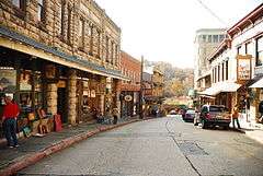
The Eureka Springs Historic District is a historic district that was listed on the National Register of Historic Places in 1970. Its boundaries are those of the city of Eureka Springs, Arkansas at the time of its listing, specifically augmented in 1979 to include its historic railroad depot. Much of the city was developed between 1880 (when several fires swept through) and 1910, when the area was the center of resort activity taking advantage of the many natural springs in the area. About 20% of the city's buildings were built in the 1890s and have a significant element of either Queen Anne or Second Empire styling, while its commercial buildings tend to have Romanesque and Italianate details. The city is one of the best-preserved turn-of-the-century resort communities in the region.[2]
See also
- National Register of Historic Places listings in Carroll County, Arkansas
-
 Arkansas portal
 -
 NRHP portal
References
- ↑ National Park Service (2009-03-13). "National Register Information System". National Register of Historic Places. National Park Service.
- ↑ "NRHP nomination for Eureka Springs Historic District (2005 update)" (PDF). Arkansas Preservation. Retrieved 2015-02-03.
| Topics | |
|---|---|
| Lists by states |
|
| Lists by insular areas | |
| Lists by associated states | |
| Other areas | |
| |