Ensenada Honda (Culebra, Puerto Rico)
| Ensenada Honda (Deep Cove), Culebra, Puerto Rico | |
|---|---|
|
Entrance to Ensenada Honda, Culebra, P.R. | |
 Ensenada Honda (Deep Cove), Culebra, Puerto Rico Ensenada Honda in Ceiba, Puerto Rico | |
| Location | Culebra, Puerto Rico |
| Coordinates | 18°18′09.7″N 65°17′10.7″W / 18.302694°N 65.286306°WCoordinates: 18°18′09.7″N 65°17′10.7″W / 18.302694°N 65.286306°W |
| Type | Bay |
| Ocean/sea sources | North Atlantic Ocean |
| Managing agency | Department of Natural and Environmental Resources, Puerto Rico Ports Authority |
| Islands | Cayo Pirata |
| Settlements | Culebra, Puerto Rico |
| Website | http://www.rooseveltroads.pr.gov/ |
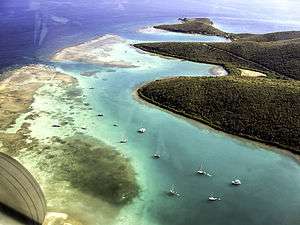
Ensenada Honda (English: Deep Cove), also known as "Puerto Grande" (English: Big Port) and "Bahía Honda" for its elongated shape, is the largest inlet on the island of Culebra, Puerto Rico.
Geography
Since the 19th century, observers have deemed Ensenada Honda among the safest Caribbean harbors.[lower-alpha 1][1][2] Its irregular coastline features rocky cliffs, sandy beaches, and mangrove forests. Three smaller inlets gate the cavernous cove: "Malena" and "Dakity" to the west, and "Mosquito" to the east. A number of distinct coral specimens inhabit the area around Culebra, and some communities have flourished at the very bay's entrance.[3] They form bars barely above sea level and block portions of its opening.
Environmental history
For most of the 20th century (1902-1975) the bay served as grounds for military training, as wreckage left from the time reveals. Explosions and the resulting contamination left pulverized underwater craters and diminished the health of sea life. But low-tech, community-based programs and coral grafting have expanded the reefs' fields and increased their bio-diversity.[4][5] The bay is today an eco-tourist destination, celebrated for its turtles, and the center of the local fishing industry.

See also
- Ensenada Honda (Ceiba, Puerto Rico)
- San Juan Bay
- Mayaguez Bay
- Culebra Island giant anole
- Flamenco Beach
Notes
References
- 1 2 Schwab, William C. and Rafael W. Rodriguez (1992). "Progress of Studies on the Impact of Hurricane Hugo on the Coastal Resources of Puerto Rico," (PDF). Report. U.S. Department of the Interior: Geological Survey. pp. 8–12. Retrieved February 10, 2016.
- ↑ Editors (1887). "Las posesiones Españolas y el Canal de Panamá". Boletín de la Real sociedad geográfica,: 354–8.
- ↑ Brook, George (1893). Catalogue of the madreporarian corals in the British Museum (Natural History). London: British Museum. p. 63.
- ↑ Sturm, Paul; et al. (2014). "Culebra Community Watershed Action Plan For Water Quality and Coral Reefs" (PDF). Report. NOOA. Retrieved February 9, 2016.
- ↑ Hernández-Delgado, Edwin A. (2014). "Bomb-cratered coral reefs in Puerto Rico, the untold story about a novel habitat: from reef destruction to community-based ecological rehabilitation". Revista Biológica Tropical. 62 (Suppl. 3).