Colorado State Highway 92
| ||||
|---|---|---|---|---|
|
Map of western Colorado with SH 92 highlighted in red | ||||
| Route information | ||||
| Maintained by CDOT | ||||
| Length: | 73.22 mi[1] (117.84 km) | |||
| Major junctions | ||||
| North end: |
| |||
| South end: |
| |||
| Location | ||||
| Counties: | Delta, Montrose, Gunnison | |||
| Highway system | ||||
|
Colorado State Highways
| ||||


State Highway 92 is a stretch of highway that runs between the small Colorado communities of Hotchkiss and Sapinero. SH 92 is 73.22 miles (117.84 km) long.[1]
Route description
From its southern terminus at U.S. Highway 50 at the town of Sapinero, the highway crosses the Gunnison River at Blue Mesa Reservoir. Proceeding westward, SH 92 quickly climbs a ridge high above the Gunnison River. This stretch of road lasts for 25 to 30 miles (48 km) before it veers northward toward Hotchkiss.
History
The route was established in the 1920s and was paved by 1975.[2]
Major intersections
| County | Location | mi | km | Destinations | Notes |
|---|---|---|---|---|---|
| Delta | Delta | 0.000 | 0.000 | ||
| Read | 3.814 | 6.138 | |||
| Hotchkiss | 20.725 | 33.354 | |||
| Gunnison | Sapinero | 73.297 | 117.960 | ||
| 1.000 mi = 1.609 km; 1.000 km = 0.621 mi | |||||
-
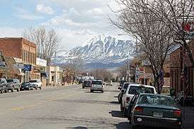
Highway 92 in Hotchkiss, Colorado.
References
- 1 2 "Segment list for SH 92". Retrieved 2008-10-19.
- ↑ Salek, Matthew E. "Colorado Routes 80-99". Retrieved 04-11-2010. Check date values in:
|access-date=(help)
External links
This article is issued from Wikipedia - version of the 2/6/2016. The text is available under the Creative Commons Attribution/Share Alike but additional terms may apply for the media files.