Colorado State Highway 389
| ||||
|---|---|---|---|---|
|
Map of Las Animas County in southern Colorado with SH 389 highlighted in red | ||||
| Route information | ||||
| Maintained by CDOT | ||||
| Length: | 12.38 mi[1] (19.92 km) | |||
| Major junctions | ||||
| North end: |
| |||
| South end: |
| |||
| Location | ||||
| Counties: | Las Animas | |||
| Highway system | ||||
|
Colorado State Highways
| ||||

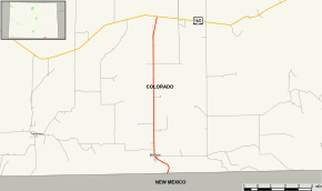
State Highway 389 (SH 389), in the U.S. state of Colorado is a state highway traversing through the Great Plains, and Black Mesa in southeastern Colorado. The route travels from US 160 through rural Las Animas county to Branson. The highway serves the Branson area and heads south to the New Mexico border 1.5 miles south, where it continues as NM 551.
Route description
State Highway 389 begins at the junction with U.S. Highway 160 between of Trinidad and Kim. It heads southward through the open prairie for 10 miles before reaching the town of Branson. While heading south before Branson, the Black Mesa comes into view; while not too far from the Comanche National Grassland. Valleys and hills surround the area, while there are no mountains.
Going southward out of Branson, several small passes up to 8,000 feet are traversed. About 1.5 miles south of Branson, the New Mexico border comes and the highway ends but continues as New Mexico State Road 551.
History
This routing was originally designated by the Colorado Department of Transportation as SH 100 (deleted) and as a portion of U.S. Highway 160. When US 160 was rerouted in 1949, the portion formerly numbered as SH 389, today's number. Several years later, the section near New Mexico State Road 551 at the border was deleted, leaving the terminus at Branson. This section was readied in 1964 and SH 389 was entirely paved a year later.[2]
Major intersections
The entire route is in Las Animas County.
| Location | mi | km | Destinations | Notes | |
|---|---|---|---|---|---|
| | 0.00 | 0.00 | |||
| | 12.38 | 19.92 | |||
| 1.000 mi = 1.609 km; 1.000 km = 0.621 mi | |||||
-
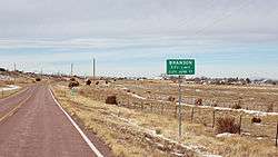
The highway just before it enters Branson, Colorado from the south.
References
- ↑ "Segment list for SH 389". Retrieved 2007-05-12.
- ↑ Salek, Matthew E. "Colorado Routes 367-399". Retrieved 2010-06-15.