Shinyanga Region
| Shinyanga Region Mkoa wa Shinyanga (Swahili) | |
|---|---|
| Region | |
|
| |
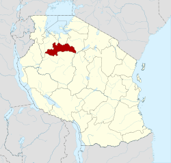 Regional map before partition in 2012 | |
| Country | Tanzania |
| Zone | Lake |
| Capital | Shinyanga |
| Government | |
| • Regional Commissioner | Ali Rufunga |
| Area | |
| • Total | 18,901 km2 (7,298 sq mi) |
| Population (2012) | |
| • Total | 1,534,808 |
| • Density | 81/km2 (210/sq mi) |
| Time zone | EAT (UTC+3) |
| Postcode | 37xxx |
| Area code(s) | 028 |
| Website |
shinyanga |

Shinyanga Region is one of Tanzania's 30 administrative regions. The regional capital is the municipality of Shinyanga. According to the 2012 national census, the region had a population of 1,534,808.[1]:page 2 For 2002-2012, the region's 2.1 percent average annual population growth rate was the twentieth highest in the country.[1]:page 4 It was also the tenth most densely populated region with 81 people per square kilometer.[1]:page 6 With a size of 50,781 square kilometres (19,607 sq mi),[2] the region is slightly smaller than Costa Rica (51,100 square kilometres (19,700 sq mi)).
The region is bordered to the north by the Mwanza, Mara, and Kagera Regions and to the south by the Tabora Region. Kigoma Region borders to the west, Singida Region to the southeast, and the Arusha and Manyara Regions to the east.
Districts
As of 2012, the region is administratively divided into five districts:[3]
| Districts of Shinyanga Region | ||||||
|---|---|---|---|---|---|---|
| Map with main roads in green | District | Population (2012 Census) | ||||
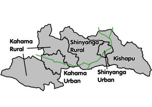 |
Kahama Rural | 523,802 | ||||
| Kahama Urban | 242,208 | |||||
| Kishapu | 272,990 | |||||
| Shinyanga Rural | 334,417 | |||||
| Shinyanga Urban | 161,391 | |||||
| Total | 1,534,808 | |||||
Culture
The predominant tribes of the Shinyanga region are the Sukuma, Nyamwezi, and Sumbwa tribes.
Economy
Traditional agriculture in the area varies, but it is often maize, cotton, and rice production.
References
- 1 2 3 Population Distribution by Administrative Units, United Republic of Tanzania, 2013 Archived June 12, 2013, at the Wayback Machine.
- ↑ "Statistical Abstract 2011, Tanzania National Bureau of Statistics". Retrieved 2014-06-24.
- ↑ "Census 2012". National Bureau of Statistics.
| Mainland | ||
|---|---|---|
| Zanzibar | ||
Coordinates: 3°45′S 33°00′E / 3.750°S 33.000°E