Gjelleråsen
Coordinates: 59°59′13.276″N 10°55′52.255″E / 59.98702111°N 10.93118194°E

| Gjelleråsen | |
|---|---|
| Village | |
| Country | Norway |
| Region | Østlandet |
| County | Akershus |
| Time zone | CET (UTC+01:00) |
| • Summer (DST) | CEST (UTC+02:00) |
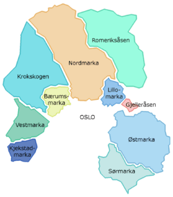
Gjelleråsen is an area which constitutes part of Oslomarka outside Oslo, Norway.[1][2]
The area is bordered by Skedsmo to the east and Nittedal to the north. There are many historic roads running through the area, and two modern highways, Norwegian National Road 4 to the north, and European route E6 to the south.[3]
The village of Gjelleråsen is known as a stopping point on Trondheimsveien, where Norwegian National Road 4 (Rv4) and join Norwegian National Road 22 (Rv22). Hagantunnelen on Norwegian National Road 4 starts at Gjelleråsen and at comes out at Slattum, where Norwegian National Road 4 runs north to Nittedal.[4]
The headquarters of Ringnes lies in Gjelleråsen. There is also the headquarters of Diplom-Is and the head office of Würth Norge. In the south of the area, towards Skedsmo, is the former Lahaugmoen military base. This was used as a historical stopping point for invasions, including that led by King Karl XII in 1716.[5]
The name of Gjelleråsen may come from Gjølluraas, or Gjoleid, which means "windy area", or from Gjøl - Gjel, which describes an inlet close to the road in the area. It may also come from the verb Gjalla, a sound as from an echo.[6]
References
- ↑ Knut Are Tvedt. "Gjelleråsen". Store norske leksikon. Retrieved September 15, 2016.
- ↑ Knut Are Tvedt. "Oslomarka". Store norske leksikon. Retrieved September 15, 2016.
- ↑ Svein Askheim. "Slattum". Store norske leksikon. Retrieved September 15, 2016.
- ↑ Svein Askheim. "Hagantunnelen". Store norske leksikon. Retrieved September 15, 2016.
- ↑ Erlend Hammer. "Lahaugmoen". Store norske leksikon. Retrieved September 15, 2016.
- ↑ "Hvorfor heter det...? From stovnerporten.no".